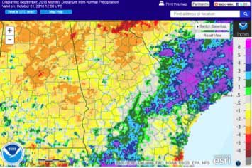
While the southern half of the state received much needed rain in September from tropical storms Hermine and Julia, farmers in the northern part of the state dealt with what some called “the worst conditions in 60 years.”
Four months of higher than normal temperatures and abnormally low rainfall left cattle and corn farmers in the northern half of the state with little to feed their herds, and many have sold off cattle. The dry, hot conditions combined with a widespread infestation of armyworms led to the loss of 80 percent of hay crops and 60 percent of soybean crops on some farms.
Despite possible rainfall generated by Hurricane Matthew in early October, drier and warmer than normal conditions are likely to continue through the rest of the year.
It was the warmest September on record for a number of stations in northern Georgia according to the Perspectives tool from the Southeast Regional Climate Center. In spite of that, only three record daily high temperatures were tied this month.
- Atlanta’s monthly average temperature was 78.8 F, 5.2 degrees above normal.
- Athens’ monthly average temperature was 77.7 F, 4.4 degrees above normal.
- Columbus’ monthly average temperature was 80.3 F, 3.7 degrees above normal.
- Macon’s monthly average temperature was 78.6 F, 3.6 degrees above normal.
- Savannah’s monthly average temperature was 79.6 F, 2.7 degrees above normal.
- Brunswick’s monthly average temperature was 79.4 F, 1.3 degrees above normal.
- Alma’s monthly average temperature was 78.5 F, 1.4 degrees above normal.
- Augusta’s monthly average temperature was 77.4 F, 2.8 degrees above normal.
- Albany’s monthly average temperature was 80.6 F, 2.9 degrees above normal.
- Rome’s monthly average temperature was 77.6 F, 5.6 degrees above normal.
- Valdosta’s monthly average temperature was 79.6 F, 2.2 degrees above normal.
Several daily rainfall records were set during the month in association with Hermine and Julia. August had a record of 4.20 inches on September 2, passing the old record of 1.12 from 2014. Alma had 3.26 inches on the same date, breaking the old record of 3.19 set in 1957. Brunswick had 4.43 inches on September 13, breaking the old record of 2.03 set in 2002.
It was the second driest September in Rome in 124 years of record, following zero inches in 1897.
The highest monthly total precipitation from National Weather Service reporting stations was 8.21 inches in Brunswick, Georgia — 2.45inches above normal — and the lowest was in Rome, Georgia, at .24 inches — 3.17 inches below normal.
- Atlanta received 3.43 inches of rain, 0.84 inches below normal.
- Columbus, Georgia, received .75 inches of rain, 1.41inches above normal.
- Macon, Georgia, received 2.18 inches of rain, 2.07 inches below normal.
- Savannah, Georgia, received 4.99 inches of rain, .41 inches above normal.
- Alma, Georgia, received 4.26 inches of rain, 0.62 inches above normal.
- Augusta, Georgia, received 4.58 inches of rain, 1.36 inches below normal.
- Albany, Georgia, received 3.29 inches of rain, 0.15 inches below normal.
- Rome, Georgia, received 6.42 inches of rain, 2.29 inches above normal.
Community Collaborative Rain, Hail and Snow Network volunteers in Valdosta reported daily rainfall amounts of 6.08 to 6.01 inches on September 2 during Hermine’s passage. A St. Simons Island volunteer reported 6.03 inches on September 14 during Julia’s movement through the area. The highest monthly rainfall of 12.80 inches was measured near Darien in McIntosh County, followed by 10.07 inches recorded on St. Simons Island in Glynn County and at Newington in Screven County.
Severe weather was observed on four days during September. Two small tornadoes were observed near Riceboro in Liberty County and near Skidaway Island in Chatham County on September 1 in spiral bands ahead of Hermine.
For more information please see the “Climate and Agriculture” blog at blog.extension.uga.edu/climate or visit our web page at www.gaclimate.org. To share your weather and climate impacts on agriculture, please feel free to email pknox@uga.edu.


