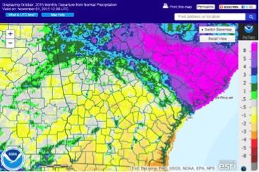
While our neighbor to the northeast, South Carolina, was left reeling from October’s floods, parts of Georgia were left with less rain than normal.
Rainfall amounts varied dramatically across the Southeast. For instance, Charleston, South Carolina, received 18.91 inches during October, while four hours away Savannah, Georgia, received just one-tenth of that. The difference is remarkable and shows how localized the rain from the South Carolina flood event was.
Georgia luckily avoided most of the problems associated with the flooding in South Carolina. The heaviest rain in Georgia from this event occurred in the northeastern mountains. Local stream flooding occurred in some locations, but was much less than the extensive flooding that occurred in South Carolina.
Farmers were generally thankful for the drier conditions they saw last month. Wet conditions helped ease drought conditions in parts of the state but also caused boll rot in some cotton plants and caused hay to rot in the fields. The rest of the month was quite dry, which allowed farmers to harvest cotton and peanuts and cure hay for the winter. At the end of the month, farmers were waiting for rain to return, so they could start planting winter cover crops and small grains.
The highest monthly total precipitation recorded by National Weather Service stations was 6.43 inches in Rome, Georgia — 2.57 inches above normal — and the lowest was in Albany, Georgia, at 0.65 inches — 1.94 inches below normal. Atlanta received 2.55 inches, 0.86 inches below normal; Athens, Georgia, received 5 inches, 1.45 inches above normal; Columbus, Georgia, received 1.07 inches, 1.51 inches below normal; Macon, Georgia, received 1.7 inches, 1.09 inches below normal; Savannah, Georgia, received 1.78 inches, 1.91 inches below normal; Augusta, Georgia, received 4.62 inches, 1.35 inches above normal; Alma, Georgia, received 3.26 inches, 0.23 inches above normal; and Valdosta, Georgia, received 1.73 inches, 1.47 inches below normal.
Two daily rainfall records were set in October. Alma received 2.51 inches on Oct. 1, breaking the old record of 0.58 inches set in 1989. Brunswick, Georgia, received 3.38 inches on the same date, surpassing the old record of 0.76 inches set in 1957.
The highest single-day rainfall amounts recorded by Community Collaborative Rain, Hail and Snow Network stations were recorded on Oct. 4 in conjunction with the South Carolina flood event. The highest rainfall amount in the state was 5.2 inches, observed northeast of Hartwell, Georgia, in Hart County on Oct. 4, followed by 5.14 inches received west of Dahlonega, Georgia, in Lumpkin County and 4.91 inches received near Sylvania, Georgia, in Screven County. The highest monthly total rainfall was 14.07 inches, observed northeast of Dillard, Georgia, in Lumpkin County.
Only two isolated wind damage reports were made in October, both on the first day of the month, but there were a few unofficial reports of wind damage on Oct. 7 in Athens where wind combined with water-logged soil to topple a handful of trees — damaging houses and causing isolated power outages.
Temperatures across the state were close to average compared to the western half of the country, which had well-above-normal temperatures. In Atlanta, the monthly average temperature was 64.1 degrees Fahrenheit, 0.8 degrees above normal; in Athens, 62.2 F, 0.8 degrees below normal; in Columbus, 66.5 F, 0 degrees below normal; in Macon, 64.3 F, 0.6 degrees below normal; in Savannah, 68.2 F, 0.3 degrees above normal; in Brunswick, 70.2 F, 0 degrees below normal; in Alma, 68.3 F, 0.1 degrees below normal; in Augusta, 64 F, 0.4 degrees below normal; in Albany, 69 F, 0.9 degrees above normal; in Rome, 61.8 F, 0.6 degrees above normal; and in Valdosta, 70.2 F, 1.5 degrees above normal. In general, the warmest temperatures were in areas where the precipitation was lowest.
One daily temperature record was broken in October. Alma reported a low of 39 F on Oct. 19, breaking the old record of 40 F, set in 2009. Macon also tied a record high of 88 F on Oct. 16, matching the observation from 1971.
The outlook for November shows an increased chance of warmer and wetter-than-usual conditions across the state, which should aid in the removal of drought throughout the state.
For more information, visit the Climate and Agriculture in the South East (CASE) blog at blog.extension.uga.edu/climate/ or visit our new Web page at gaclimate.org. Please feel free to email your weather and climate impacts on agriculture to share on the blog to pknox@uga.edu.


