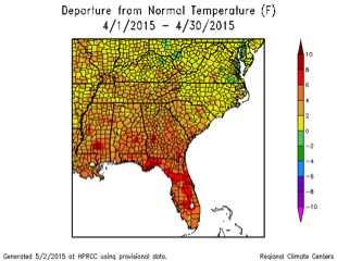
April 2015 was much warmer and wetter statewide than is usual for the month. The wet conditions caused delays in planting and contributed to some crop disease pressure, while the warm conditions accelerated the growth of plants, like corn, that were already in the ground. While statewide statistics will not be available until later this month, this April is expected to be one of the warmest Aprils on record for Georgia, coming close to the record of 67.9 degrees Fahrenheit set in 2002.
Temperatures across the state were well-above normal in April. In Atlanta, the monthly average temperature was 65.7 F, 3.7 degrees above normal; in Athens it was 65.1 F, 3.4 degrees above normal; in Columbus it was 67.9 F, 3.3 degrees above normal; in Macon it was 66.9 F, 3.5 degrees above normal; in Savannah it was 70.3 F, 4.7 degrees above normal; in Brunswick it was 70.5 F, 4.0 degrees above normal; in Alma it was 70.2 F, 4.1 degrees above normal; in Augusta it was 66.3 F, 3.6 degrees above normal; in Albany it was 70.7 F, 4.5 degrees above normal; and in Valdosta it was 71.5 F, 5.6 degrees above normal.
Several records for daily temperatures were broken this month. Atlanta and Athens broke daily record highs on April 8 with 87 F and 89 F temperatures, respectively. This surpassed Atlanta’s old record of 85 F, set in 1978, and Athens’ old record of 88, set in 1919. Alma also tied their record high of 89 F for that date. Savannah broke their record for highest minimum temperature on April 14 with a low of 70 F, just above the old record of 68 F set in 1947. Brunswick also set a record with a high minimum temperature on April 11, with the value of 69 F beating the old record of 68 F, set in 2013.
The high temperature records were enough to put some individual National Weather Service (NWS) reporting stations in the top 10 rankings for average temperature for April. According to the April summary provided by NWS in Peachtree City, Athens was the sixth warmest station on record, tied with Atlanta. Columbus was 12th warmest, and Macon was the 14th warmest on record.
The highest total precipitation for the month, based on data from the NWS reporting stations, was 8.01 inches in Athens—4.86 inches above normal—and the lowest was Brunswick’s 3.43 inches—0.94 inches above normal. Atlanta received 7.79 inches, 4.43 inches above normal; Augusta received 4.86 inches, 2.02 inches above normal; Macon received 6.27 inches, 3.31 inches above normal; Columbus received 6.47 inches, 2.92 inches above normal; Savannah received 6.52 inches, 3.45 inches above normal; Alma received 3.65 inches, 0.84 inches above normal; Valdosta received 4.84 inches, 1.97 inches above normal; and Albany received 5.18 inches, 1.54 inches above normal.
According to the NWS Peachtree City station summary, this was the seventh wettest April for Athens and the eighth wettest for Atlanta. It was the 15th wettest April for Macon, and the 19th wettest for Columbus.
The highest single-day rainfall, according to Community Collaborative Rain, Hail and Snow Network (CoCoRaHS) stations, was 3.70 inches received northeast of Midway in Liberty County on April 29, followed by 3.48 inches received northeast of Nelson in Pickens County and 3.46 inches received south of Nahunta in Brantley County on the same date. The highest monthly total rainfall was 12.05 inches, observed near Stockbridge in Henry County, followed by 10.42 inches observed near McDonough in the same county.
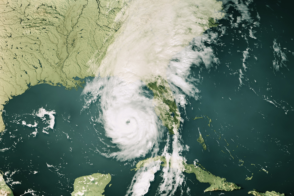
After a slow start to the severe weather season earlier this year, Georgia experienced plenty of severe weather in April. Severe weather was observed somewhere in the state during one five-day stretch. An EF-1 tornado was observed on April 3 in Dade County in far northwest Georgia. Several additional tornadoes were observed on April 19-20 across the state. A description of the events can be found at www.srh.noaa.gov/ffc/?n=20150420_severe_weather and nws.weather.gov/blog/nwsjacksonville/2015/04/20/.
The wet conditions caused delays in planting across many areas of the state. Winds and rain caused lodging and increased disease pressure in some crops. Harvest of ryegrass for hay and silage was also delayed due to the wet conditions, although pastures in general are doing well due to all the rain. The warm temperatures caused rapid growth in places where crops were already in the ground before the spate of wet days at the end of the month. Farmers were forced to use aerial spraying in some cases to get agricultural chemicals and fertilizer into the fields to help with corn and development of other crops. Some farmers may switch from corn to cotton for the last few acres due to the late planting.
The outlook for May shows a slightly increased chance of cooler and wetter conditions than normal. The three-month outlook shows that there are nearly even chances for above, below or near-normal temperatures for the next three months, but that wet conditions are likely to continue under the influence of the El Niño.
For more information, please see the Climate and Agriculture in the South East blog at blog.extension.uga.edu/climate/ or visit our new Web page at gaclimate.org. Please feel free to email your weather and climate impacts on agriculture to share on the blog to pknox@uga.edu.