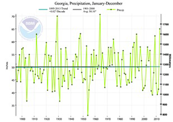
With 65 inches of rain observed statewide, conditions in Georgia were much wetter than usual in 2013. The state as a whole received its third largest annual total precipitation since state records began in 1895.
Rainfall in 2013 was almost 15 inches above the annual average calculated between 1901-2000. The heavy precipitation helped Georgia continue a two decade record of years with highly variable rainfall and ended the third major drought Georgia has experienced since 1998.
While Georgia’s farmers usually welcome the rain, this year was so cloudy that the lack of sunshine delayed the development of some key crops. The wet conditions also delayed spring planting and other fieldwork due to the persistently wet soils around the state. Conversely, the wet and cool spring and summer helped consumers enjoy lower utility bills.
Rainy from the beginning
This year’s wet weather began in January and February, when a strong and persistent band of rain moved into the state from north to south. This rain event helped smash the old state record for February precipitation. February 2013 saw a state average of 9.92 inches, surpassing the old record of 8.73 inches set in 1939 by more than ten percent.
The wet pattern seen in February continued into the spring and summer, contributing to cool and cloudy conditions through most of the growing season. During the year, Macon set a new record for annual rainfall with the National Weather Service station recording 72.91 inches at that location, 27.23 inches above normal. This was more than double the amount of rain they received in 2013 at 32.41 inches.
While other cities didn’t set records, they were still much wetter than normal. Atlanta received 66.02 inches (16.31 inches above normal); Athens received 59.89 inches (13.56 above normal); Columbus received 62.65 inches (15.90 above normal); Savannah received 54.07 inches (6.11 above normal); Augusta received 55.52 inches (11.95 above normal); Alma received 52.47 inches (5.82 above normal); and Brunswick received 52.05 inches (7.05 above normal).
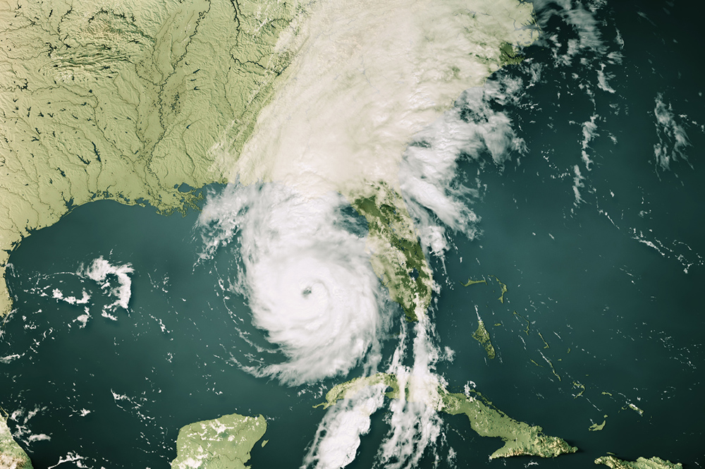
Surprisingly, all of this near-record rainfall occurred in a year with very little tropical storm activity. Normally tropical storms that pass through or near Georgia can contribute up to 25 percent of our rainfall during the tropical season, between June and the end of November. This year, Georgia was only brushed by two tropical storms, Tropical Storm Andrea in early June and Tropical Storm Karen in early October. In spite of forecasts for an active hurricane season, the number of tropical systems was much lower than expected due to a strong outflow of Saharan dust from the west coast of Africa, which stifled the development of tropical storms this year in spite of favorable non-El Nino conditions.
Unseasonably cool but then unseasonably warm
Spring of 2013 was the sixth coldest spring since 1895 and the coldest since 2005. It was especially noticeable after the record-setting spring of 2012, which was 7 degrees warmer than 2013. Cooler than normal conditions continued through the summer of 2013, but this pattern reversed in the fall, when warm and dry conditions covered most of the state.
The year as a whole ended up slightly cooler than the long-term average in temperature. The end of the year was marked by the lack of strong El Nino or La Nina conditions in the eastern Pacific Ocean. These neutral conditions helped set up wide swings in weather conditions in early winter and are continuing on into 2014.
January 2013 saw unusual weather patterns with a prolonged period of warmer than normal conditions in the middle of the month. The state average temperature was the warmest it has been since 1974. It was only the second time since 1960 that the state average temperature for January surpassed 52 F.
Other notable weather patterns in 2013 were the absence of heat waves during the summer and the unusual cold snap in mid-August that brought October-like temperatures to much of the state for several days. A cold snap also occurred near Thanksgiving across northern Georgia, leading to temperatures as low as 13 degrees near Elberton. Some snow was reported near Atlanta and in northern counties on November 27. This is only the third time since records began that Atlanta received measurable snow in November. Daily low temperature records were set at many locations on the mornings of November 14, 27 and 28.
Those record lows were followed by a December marked by a warm flow moving in from the south, which brought record-setting high day and nighttime temperatures to many areas of the state. Some of the warmest temperatures occurred overnight ahead of a vigorous cold front. Savannah tied their all-time maximum temperature of 83F on two days in December and many other cities set daily records.
Georgia as a whole experienced less severe weather than usual due to the cool conditions during the peak spring severe weather season. However, a tornado outbreak on March 18 — which began in eastern Louisiana and moved into Mississippi, Alabama and Georgia — included two tornadoes that hit central Georgia as well as numerous hail and strong wind reports. The entire storm system caused about $7 billion worth of damage across the U.S. in 2013, according to the National Climatic Data Center.
Another year of variable weather?
In 2014 Georgians can expect more highly variable weather conditions through the rest of the winter and into the spring, due to the lack of an El Nino or La Nina. This means that Georgia is likely to go through periods of relative warmth as well as significant cold spells for the next few months. This increases the likelihood of a snow or ice storm in the next two to three months, particularly in north Georgia. It also increases the likelihood of a late frost, which could damage crops and flowers that are planted early.
Early forecasts for the coming year indicate that El Nino is likely to develop in mid- to late summer in the eastern Pacific Ocean and could affect fall and winter conditions next year. Statistically, in an El Nino winter, Georgia is likely to experience wetter and cooler conditions than normal due to the presence of a strong jet of air from the tropics, which brings active weather — including clouds and rain — to the southeastern U.S. Tropical storm activity is likely to be reduced in El Nino summers.