December was warm and wet across most of Georgia, a change from the cold and dry conditions that dominated November. Warm daytime high temperatures and higher than normal nighttime lows broke records.
Surges of warm air from the Southwest kept the state warmer than normal. Some of the warmest temperatures occurred overnight, as strong winds brought record-setting temperatures to much of the state.
On Dec. 5, observers at several National Weather Service stations saw record-breaking temperatures in Atlanta, Athens, Columbus and Savannah. Temperatures in Alma and Augusta tied historical record highs on Dec. 6 as a wave of warm air continued to move east.
On Dec. 22, another stream of warm air moved into the state and broke records. In Savannah, the daytime temperature hit 83 degrees — breaking the city’s all-time, record-high temperature for December, which was set two weeks earlier on Dec. 6. Records for high nighttime lows were also set on Dec. 6 in Atlanta, Athens and Columbus, and in Savannah, Augusta and Alma on Dec. 22.
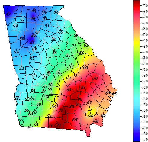
In Atlanta, the monthly average temperature was 48.1 degrees (2.8 degrees above normal); in Athens it was 47.6 degrees (2.2 above normal); in Columbus it was 51.5 degrees (2.4 above normal); in Macon it was 50.4 degrees (2.4 above normal); in Savannah it was 57.3 degrees (5.6 above normal); in Brunswick it was 57.9 degrees (3.8 above normal); in Alma it was 56.5 degrees (3.9 above normal); and in Augusta it was 50.3 degrees (3.1 above normal).
The highest monthly total precipitation reported by an National Weather Service observer was 9.04 inches in Macon (5 inches above normal) and the lowest was in Brunswick with 1.88 inches (0.76 inches below normal). Atlanta received 7.8 inches (3.9 inches above normal); Athens received 7.62 inches (3.89 above normal); Savannah received 2.38 inches (0.57 below normal); Augusta received 6.9 inches (3.51 above normal); Columbus received 8.87 inches (4.6 above normal); and Alma received 2.83 inches (0.46 below normal).
Atlanta observers reported a record-high daily rainfall total on Dec. 22 of 3.12 inches. This surpassed the daily record of 1.78 inches set in 1907.
The highest, single-day rainfall from Community Collaborative Rain, Hail and Snow Networks stations was 5.88 inches, recorded near McDonough in Henry County on Dec. 23. Another observer, near Woolsey in Fayette County, reported 5.6 inches on the same date. The highest monthly total rainfall recorded by a CoCoRaHS observer was 14.01 inches west of Clayton in Rabun County, followed by 13.3 inches measured near Cedartown in Polk County.
The U.S. Army Corps of Engineers noted this was the wettest December in the Thurmond Dam sub-basin since records began in 1948. Reservoir levels rose rapidly during the month as rainfall continued across the basin. This put reservoir levels above the summer full-pool levels and into flood storage. Some recreation areas, including boat ramps and fishing piers on J. Strom Thurmond Lake, were temporarily closed due to the impact of the high water levels.
December’s wet weather helped set annual precipitation records for 2013 - already one of the wettest on record. Macon broke its all-time yearly record with 72.91 inches in 2013 - 27.23 inches above normal. This is more than double the 32.41 inches the area received in 2012.
A National Weather Service cooperative observer in Helen reported 101.42 inches of rain, the third-highest annual total ever recorded at an official NWS co-op site. A nearby observer at Sautee reported 98.58 inches, the fifth-highest annual total ever reported for Georgia.
These amounts, as well as records seen at other stations in Georgia, are still being verified and will be discussed in the annual summary released later this month.
Isolated wind damage was reported on Dec. 5 and Dec.14. Two Cobb County house fires were linked to lightning damage on Dec. 22.
Despite its warm start, wide variations in winter weather are expected to continue for the rest of the season due to the absence of El Nino or La Nina conditions in the eastern Pacific Ocean. Neutral conditions are expected to continue through at least August. Gardeners should note that neutral winters and springs bring an increased chance of a late frost.