In spite of record-setting high temperatures at the end of the month, June was slightly cooler than normal in Georgia. Rainfall across the state varied greatly as Tropical Storm Debby dumped more than 10 inches on the southern half, but left north Georgia dry.
In Athens the average temperature was 75.4 degrees Fahrenheit (2.1 degrees below normal), Columbus was 79.4 (0.4 below normal), Macon was 77.1 (1.8 below normal), Savannah was 77.4 (2.4 below normal), Brunswick was 78.3 (2.0 below normal), Alma was 77.8 (1.9 below normal) and Augusta was 74.7 (3.9 below normal).
However, the monthly average temperature for Atlanta was 77.4 degrees (0.1 degrees above normal).
June saw records set for both high and low temperatures in different parts of the state, with record low temperatures set in Macon, Augusta, Savannah and Brunswick on June 27.
That night Macon reported a temperature of 57 degrees, breaking the June 27, 1946 record of 62 degrees. Savannah reported a low of 61 degrees on the 27 and 63 degrees on the 28, breaking daily low-temperature records of 63 degrees, set on June 27, 1979 and 64 degrees, set on June 28, 1968. Augusta reported 56 degrees, breaking the 1979 record of 61 degrees, and Brunswick reported 63 degrees, which broke the 1979 record of 65 degrees.
Less than two days later, some of the same cities broke their all-time high temperature records. The late June heat wave was caused by a large high-pressure system spreading across the eastern U.S.
Atlanta set new record highs of 106 degrees on June 30, breaking the old all-time record of 105 set in 1980 and smashing the old daily record of 98 degrees set in 1936. Athens reported a new all-time record of 109 degrees on June 29 and also broke daily high-temperature records for the dates on June 29 and 30.
Columbus set a new all-time high temperature record of 106 degrees on June 30, which surpassed the record-setting 105-degree temperature the city saw on June 29. The old high-temperature record had been 104, which was set in 1978.
Macon tied its all-time high-temperature record of 108 degrees, from 1980, on June 30.
The cooler temperatures and more frequent showers in early June reduced drought levels across many parts of Georgia during the first three weeks of the month. However, the dry conditions coupled with the extremely hot temperatures at the end of month reversed that trend, and drought started to expand across northern and central Georgia again by the beginning of July.
National Weather Service stations reported that the highest monthly precipitation total occurred in Brunswick, with 11.40 inches (6.56 inches above normal). The least amount was in Columbus, which saw only 2.18 inches of rain (1.54 below normal).
Augusta received 2.48 inches (2.24 inches below normal), Atlanta 2.28 received (1.67 below normal), Alma received 4.56 (0.82 below normal), Athens received 2.95 (1.23 inches below normal), Macon received 3.04 (1.02 below normal) and Savannah received 3.19 (2.46 below normal).
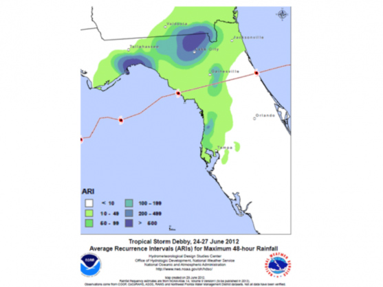
The highest single-day rainfall from Community Collaborative Rain, Snow and Hail Network stations was 6.64 inches on June 26 in southeast Georgia near Lake Park in Lowndes County from Tropical Storm Debby. The second highest daily total reported by the network was 6.34 inches on June 25 reported at Kingsland in Camden County from the same storm.The Kingsland observer also had the highest monthly total of 17.95 inches. The second and third highest monthly totals were 15.54 inches reported south of Nahunta in Brantley County and 14.62 inches by the Lake Park observer.
Severe weather was reported for eight days in June. The reports were mainly due to wind damage, although hail was also reported in a few locations.
Flash flooding occurred in Thomasville on June 6, when five to six inches of rain fell near town in just an hour and a half. The rain caused power outages, water damage to some local businesses and slightly injured a 12-year-old boy who was sucked into an underwater, manhole but was rescued by police and fire officials.
Tropical Storm Debby passed south of Georgia through the peninsula of Florida late in the month. Unfortunately for drought-stricken areas of Georgia, the rainfall from Debby was confined to areas along the Georgia and Florida border and in the southeastern corner of the state.
Crop conditions in Georgia improved during June due to the more moderate temperatures and timely showers early in the month. A few farmers were even hindered from field work by wet conditions in their fields. However, the hot and dry conditions at the end of the month reduced soil moisture across most of the state and increased stress on many crops in areas that were not reached the rain associated with Tropical Storm Debby.